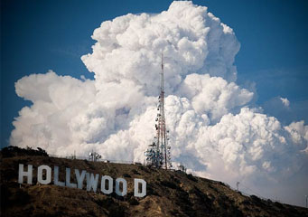
Above: Pyrocumulus Clouds
- Home
- Types of Clouds
- Accessory Clouds
- Altocumulus Castellanus Clouds
- Altocumulus Clouds
- Altostratus Clouds
- Anvil Clouds
- Anvil Dome Clouds
- Anvil Rollover Clouds
- Arcus Clouds
- Backsheared Anvil Clouds
- Cirrocumulus Clouds
- Cirrostratus Clouds
- Cirrus Clouds
- Clear Slot Clouds
- Cloud Tags Clouds
- Collar Clouds
- Condensation Funnel Clouds
- Congestus Clouds
- Cumulogenitus Clouds
- Cumulonimbogenitus Clouds
- Cumulonimbus Clouds
- Cumulus Clouds
- Debris Clouds
- Dry Slot Clouds
- Duplicatus Clouds
- Fallstreak Hole Clouds
- Funnel Clouds
- Hail Fog Clouds
- Hot Tower Clouds
- Incus Clouds
- Inflow Band Clouds
- Intortus Clouds
- Inverted Cumulus Clouds
- Knuckles Clouds
- Lacunosus Clouds
- Mammatus Clouds
- Nacreous Clouds
- Nimbostratus Clouds
- Noctilucent Clouds
- Opacus Clouds
- Pannus Clouds
- Perlucidus Clouds
- Pileus Clouds
- Praecipitatio Clouds
- Pyrocumulus Clouds
- Radiatus Clouds
- Roll Clouds
- Rope Clouds
- Scud Clouds
- Shelf Clouds
- Species Fractus Clouds
- Stratocumulus Clouds
- Stratus Clouds
- Striations Clouds
- Tail Clouds
- Towering Cumulus Clouds
- Translucidus Clouds
- Tuba Clouds
- Undulatus Clouds
- Velum Clouds
- Vertebratus Clouds
- Wall Clouds
Pyrocumulus Clouds
If you know nothing about pyrocumulus clouds, then this article will certainly help you out.
Pyro is the Latin word for “fire”, while cumulus means “heap” or “pile up”, consequently, pyrocumulus clouds are clouds in the form of cumulus clouds which are produced from fire either by volcanic eruption or wildfire. Simply put, pyrocumulus is a fire cloud that occurs as a result of surface heating created by fire. It is quite ironic that the cloud fashioned by fire can produce rainfall that could help turn off the flames. However, these clouds may further develop into thunderstorm clouds that can make lightning which may likewise trigger more blaze. In addition, pyrocumulus clouds also appear as a result of nuclear weapons detonation.
At What Height is Pyrocumulus Clouds Found?
These clouds can be found anywhere between 2,000 feet to 30,000 feet above the ground. Pyrocumulus clouds can be made up of ashes from the volcanic eruption or fire. And strong turbulence should also be expected from the cloud. Sometimes, pyrocumulus clouds can produce rain or storm that could help extinguish the fire below. The precipitation may be persistent especially in subtropical zones where condensation often results due to the large amount of moisture in the air. Subsequently, pyrocumulus clouds can grow into cumulonimbus clouds and set off further outbursts of fire.
How does a Pyrocumulus Cloud Form?
Pyrocumulus cloud is created due to the atmospheric convection produced by fire. It occurs as a result of intense surface heating created by fire that produces vigorous lifting of air currents and the huge amount of water vapor released by the vegetation and air during combustion. The rising warm air lifts the water vapor until it reaches condensation level and form cumulus clouds riding over the fire. The base of a pyrocumulus cloud is obscure due to the smoke coming from the fire or eruption, but the summit is apparent over the smokescreen.
What do Pyrocumulus Clouds Look Like?
Pyrocumulus clouds appear like cumulus clouds but in brown or grayish brown color. The somber shade is a result of the smoke and ashes the cloud contains coming from the fire. Besides, it tends to spread out because ashes within the cloud increase the quantity of condensation nuclei thereby initiating condensation. Consequently, this could develop into cumulonimbus cloud which is capable of producing lightning that can spark another fire outburst. Sometimes, pyrocumulus clouds exhibit a clear color when there is extremely little wind which allows the rising air to reach condensation level without excessively mixing with the surrounding air.
How common are Pyrocumulus Clouds?
Pyrocumulus clouds are seen in places where incidences of wildfires are very common. Regions that are prone to wildfire include the French Riviera, southeastern Australia, and California in the United States.
Pyrocumulus clouds are indeed awesome, but at the same time, terrifying to behold. This cloud type is a product of heat from wildfire, volcanic eruption or nuclear blast. It is capable of either controlling the fire that created it through the precipitation that ensues, or stoke up new fire by the lightning it releases. Either way, pyrocumulus clouds is a classic manifestation of nature’s power.
