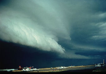
Above: Arcus Clouds
- Home
- Types of Clouds
- Accessory Clouds
- Altocumulus Castellanus Clouds
- Altocumulus Clouds
- Altostratus Clouds
- Anvil Clouds
- Anvil Dome Clouds
- Anvil Rollover Clouds
- Arcus Clouds
- Backsheared Anvil Clouds
- Cirrocumulus Clouds
- Cirrostratus Clouds
- Cirrus Clouds
- Clear Slot Clouds
- Cloud Tags Clouds
- Collar Clouds
- Condensation Funnel Clouds
- Congestus Clouds
- Cumulogenitus Clouds
- Cumulonimbogenitus Clouds
- Cumulonimbus Clouds
- Cumulus Clouds
- Debris Clouds
- Dry Slot Clouds
- Duplicatus Clouds
- Fallstreak Hole Clouds
- Funnel Clouds
- Hail Fog Clouds
- Hot Tower Clouds
- Incus Clouds
- Inflow Band Clouds
- Intortus Clouds
- Inverted Cumulus Clouds
- Knuckles Clouds
- Lacunosus Clouds
- Mammatus Clouds
- Nacreous Clouds
- Nimbostratus Clouds
- Noctilucent Clouds
- Opacus Clouds
- Pannus Clouds
- Perlucidus Clouds
- Pileus Clouds
- Praecipitatio Clouds
- Pyrocumulus Clouds
- Radiatus Clouds
- Roll Clouds
- Rope Clouds
- Scud Clouds
- Shelf Clouds
- Species Fractus Clouds
- Stratocumulus Clouds
- Stratus Clouds
- Striations Clouds
- Tail Clouds
- Towering Cumulus Clouds
- Translucidus Clouds
- Tuba Clouds
- Undulatus Clouds
- Velum Clouds
- Vertebratus Clouds
- Wall Clouds
Arcus Clouds
Clouds appear in different shapes and forms. Some are nice-looking, while some are frightening. But there is a rare type of cloud formation that will surely capture your attention – the arcus clouds. What do these clouds stand for and what do they say about the weather? Let's find out.
Arcus clouds are clouds belonging to the accessory cloud variety whose development and subsistence depend on a parent cloud. Arcus cloud is the horizontal cloud structure you see along the front base of thunderstorm-producing cloud, cumulonimbus. It may or may not be attached to the cumulonimbus cloud and it does not initiate tornado production.
Classification of Arcus Clouds
Arcus clouds come in two forms, namely, roll clouds and shelf clouds. Let’s examine how they differ from one another.
- Roll cloud
This type of arcus cloud has low and long horizontal tube-shaped cloud rolling along the front base of a cumulonimbus cloud and is completely detached. The presence of roll clouds is a strong indication of microburst activity happening in the atmosphere. Roll clouds, however, is incapable of producing tornadoes.
- Shelf Cloud
This arcus type cloud is characterized by a low-level, horizontal, wedge-shaped cloud. While roll cloud is detached from the cumulonimbus cloud, shelf cloud is attached onto the base of the cumulonimbus cloud. Oftentimes, the outer part of the cloud is in rising motion while the base is curved upward, appearing wind-torn and turbulent. Shelf cloud is sometimes confused as wall cloud. However, shelf cloud develops on a storm’s leading edge while a wall cloud grows on the rear part of a thunderstorm. Besides, wall clouds can produce tornadoes while shelf clouds cannot.
AT what Height are Arcus Clouds Found?
These fascinating cloud formations develop at low level atmospheric altitude. Low level clouds develop near the ground up to 6,500 feet and bring rain and thunderstorms.
How are Arcus Clouds formed?
Arcus cloud develops when the cool air from the storm sinks and spreads throughout the cloud surface. The outpouring of cool air inhibits the warm air to be pulled into the updraft or warm rising air of the storm. As cool air raises the warm moist air, water condenses and creates a horizontally rolling cloud due to wind shear. The underside of arcus cloud appears ragged due to a strong and abrupt gust front. In severe cases, horizontal loops are seen along the outer edge with winding cloud masses that can reach onto the ground. When these signs arrive with extremely low arcus shelf cloud, a potentially strong wind storm is fast approaching.
How do Arcus Clouds look like?
These clouds appear like long, low-level, horizontal rolls stretching over the sky preceding a thunderstorm cloud. The outer edge can be smooth or terraced while the underside can be concaved upward. Whether it’s a roll or shelf cloud, it is a warning sign of impending thunderstorm.
How common are Arcus Clouds?
Roll-type arcus clouds are relatively rare. On the other hand, shelf clouds are quite common on the façade of cumulonimbus clouds. Arcus clouds are commonly seen along coastal regions although they can also be found in non-coastal areas.
So whenever you see long horizontal clouds rolling at the base of cumulonimbus clouds, you are looking at arcus clouds and that means heavy rainfall can come anytime soon.
