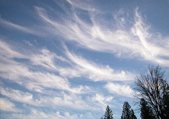
Above: Cirrus Clouds
- Home
- Types of Clouds
- Accessory Clouds
- Altocumulus Castellanus Clouds
- Altocumulus Clouds
- Altostratus Clouds
- Anvil Clouds
- Anvil Dome Clouds
- Anvil Rollover Clouds
- Arcus Clouds
- Backsheared Anvil Clouds
- Cirrocumulus Clouds
- Cirrostratus Clouds
- Cirrus Clouds
- Clear Slot Clouds
- Cloud Tags Clouds
- Collar Clouds
- Condensation Funnel Clouds
- Congestus Clouds
- Cumulogenitus Clouds
- Cumulonimbogenitus Clouds
- Cumulonimbus Clouds
- Cumulus Clouds
- Debris Clouds
- Dry Slot Clouds
- Duplicatus Clouds
- Fallstreak Hole Clouds
- Funnel Clouds
- Hail Fog Clouds
- Hot Tower Clouds
- Incus Clouds
- Inflow Band Clouds
- Intortus Clouds
- Inverted Cumulus Clouds
- Knuckles Clouds
- Lacunosus Clouds
- Mammatus Clouds
- Nacreous Clouds
- Nimbostratus Clouds
- Noctilucent Clouds
- Opacus Clouds
- Pannus Clouds
- Perlucidus Clouds
- Pileus Clouds
- Praecipitatio Clouds
- Pyrocumulus Clouds
- Radiatus Clouds
- Roll Clouds
- Rope Clouds
- Scud Clouds
- Shelf Clouds
- Species Fractus Clouds
- Stratocumulus Clouds
- Stratus Clouds
- Striations Clouds
- Tail Clouds
- Towering Cumulus Clouds
- Translucidus Clouds
- Tuba Clouds
- Undulatus Clouds
- Velum Clouds
- Vertebratus Clouds
- Wall Clouds
Cirrus Clouds
Looking at the clear sky, you saw a feathery cloud extending all over the atmosphere and wonder; what type of cloud is this? In all probability, you are gazing at cirrus clouds. These clouds are closely associated to fair weather, but did you know that they also indicate a forthcoming weather condition? Read on to learn more.
Cirrus clouds are first indicators of an upcoming weather system. However, it does not produce rainfall because it is largely made of ice crystals because the temperature at high elevation is below freezing point. Cirrus clouds are the most delicate looking clouds and also a strong indication of atmospheric humidity.
At What Altitude is Cirrus Cloud Found?
Cirrus cloud belongs to high-level clouds, which means it is found above 20,000 feet or 6,000 meters from the ground. At this atmospheric level, temperatures are very low that is why moisture freezes into ice crystals instead of forming into water droplets. Although it is closely associated as fair weather cloud, if they are large enough, cirrus clouds may signify upcoming frontal system. It may also indicate a decayed thunderstorm.
Appearance of Cirrus Clouds
Cirrus is a Latin word which means “wisp of hair” aptly describing the high-level cloud formations stretching all over the sky in subtle strands. Cirrus clouds appear like fibrous and thread-like clouds closely resembling hair curls. They are thin and transparent in white color due to their ice crystals composition. Patterns of cirrus clouds largely differ depending on the inconsistent wind flow in vertical and horizontal directions. Normally, these clouds are the first cloud warning about an upcoming warm front.
Formation of Cirrus Clouds
A cirrus cloud is formed from atmospheric turbulence resulting from strong vertical alteration of wind direction. This happens when a weather frontal system is advancing and stable air rises. Cirrus clouds also develop when water vapor experiences deposition and form ice crystals. Blowing out of ice crystals from cumulonimbus clouds or other high-reaching clouds can lead to cirrus cloud formation as well.
Classification of Cirrus Clouds
Cirrus clouds are further classified into species and varieties. Let’s consider each one of them closely.
- Cirrus Radiatus
This cloud is characterized by long parallel bands or lines of clouds radiating from the horizon. Cirrus radiatus is the less common type of cirrus cloud but is very dramatic.
- Cirrus Fibratus
Cirrus Fibratus cloud appears in thin threads or fibers. They sometimes develop from aircraft contrails and stay for quite some time.
- Cirrus Uncinus
This type of cirrus cloud has distinctive hooked-shaped threads or fibers. It closely resembles the tail of a horse as a result of strong winds underneath the cloud level where ice crystals are formed.
- Cirrus Spissatus
Cirrus spissatus is characterized by dense cirrus clouds appearing like patches that cover large portions of the sky. It’s a strong indication of incoming warm frontal weather system in the next 48 hours.
- Cirrus Castellanus
From the Latin word castellanus, meaning “small towers”, cirrus castellanus exhibits tower-like formations.
- Cirrus Floccus
Cirrus floccus cloud appears in worn-out, flaked, and puffy patches.
- Cirrus Intortus
This cloud is characterized by entwined or twisted patches.
- Cirrus Vertebratus
When you see clouds resembling fish bones or ribs, you are looking at cirrus vertebratus.
- Cirrus Duplicatus
This cloud is distinguished by multiple layers of cirrus clouds on top of each other.
- Cirrus Mamma
Cirrus mamma clouds have sac-like extensions at the underside.
How common are Cirrus Clouds
These clouds are common worldwide especially during summertime. Even so, they are also visible during winter time.
Whenever you see cirrus clouds in the sky, chances of rain should be expected within a couple of days. But for the mean time, you can enjoy the outdoors with the fair weather.
