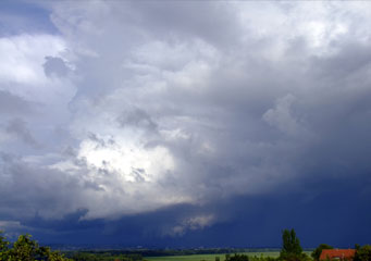
Above: Cumulonimbus Praecipitatio
Cumulonimbus Praecipitatio
Cumulonimbus praecipitatio is not only a cloud formation but also the precipitation coming from the cloud in the form of rain, hail or snow. Essentially cumulonimbus praecipitatio describes a visual effect of the cloud and the water falling from it, making it difficult to discern where the cloud base stops and the rainfall starts.
What are cumulonimbus praecipitatio clouds?
Cumulonimbus clouds are a higher and potentially more likely cause of rainfall and in some cases severe weather. Cumulus clouds form naturally even when there is high pressure, normally from the early afternoon until dusk, but will normally dissolve as the cooler air of the evening stops the convection of moist air to higher levels happening. A cumulonimbus praecipitatio effect will occur if the cumulonimbus cloud can build up enough altitude from its base and contain enough moisture to cause a cloud burst.
What height are cumulonimbus praecipitatio clouds found?
Strictly speaking cumulonimbus praecipitatio clouds can be found from ground level to about 1,000 feet. However, considering that a strong cloud burst that causes the cumulonimbus praecipitatio effect, it makes it impossible to discern where the cloud base stops and the rainfall starts. Therefore it should be considered that the height can be from ground level to upwards of 29,000 feet.
Classification of cumulonimbus praecipitatio clouds
WMO (World Meteorological Organization) classifies cumulonimbus praecipitatio clouds in the Cb category as a subset of cumulus clouds. The subset that is cumulonimbus praecipitatio is the classification used when the cumulonimbus cloud is raining heavily enough to affect visibility and make the cloud and its precipitation appear as one.
How are cumulonimbus praecipitatio clouds formed?
Thermal updrafts in particular during the temperate months of spring, summer and autumn are the most likely conditions to cause cumulonimbus praecipitatio clouds to form. They are not only restricted to tropical or warm climates, but can also be caused by moist air from the ocean moving over warmer ground driven by the winds. A fast development of the cumulonimbus cloud is needed to ensure that it contains a sufficient amount of water to cause the cumulonimbus praecipitatio effect.
What do cumulonimbus praecipitatio clouds look like?
Understanding what cumulonimbus praecipitatio clouds look like will help you decide what evasive action you need to take. Viewed from the ground it will appear that the middle of the cloud has reached down to the ground. Take note of the following indications that you are looking at to confirm that you are seeing cumulonimbus praecipitatio clouds:
- You will see a cloud that appears to be stretching down to the ground
- Strong winds will be blowing towards the cumulonimbus praecipitatio clouds
- Visual markers such as hills, tall buildings and church spires will progressively become obscured confirming the storm is moving in your direction
How common are cumulonimbus praecipitatio clouds?
Wherever strong cloudbursts take place or thunderstorms, cumulonimbus praecipitatio clouds will be able to be seen. This makes them very common and most people will be able to see them quite a few times during the year.
Where can I see cumulonimbus praecipitatio clouds?
At ground level is the best place to see cumulonimbus praecipitatio clouds. If you are flying your plane at low level and see these clouds, take evasive action immediately.
