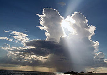
Above: Cumulonimbus Calvus
Cumulonimbus Calvus
A cumulonimbus cloud looks like a dark long funnel that stretches across the sky and its base can be several miles long. When these clouds reach a height of ten miles, high speed winds and thunderstorms caused by the rising temperatures flatten out the top to form an anvil-like shaped type of cloud. Cumulonimbus are tall clouds often found towering up in the sky and their tops normally constitute of ice particles while their bottoms appear rather dense, normally assuming a grayish cast.
What are cumulonimbus calvus?
Calvus clouds are fairly tall clouds which are capable of precipitation, though yet to develop the characteristic cumulonimbus anvil-shaped top. These types of clouds have a distinctive round shape and fairly sharp edges at the top. Normally, they develop from cumulus congestus and their further development while under favorable conditions form the cumulonimbus capillatus clouds.
What height are cumulonimbus clouds found?
Calvus clouds occur when atmospheric instability and conventions combine to push the cumulonimbus clouds beyond the congestus stage and are formed at the heights of thirty thousand feet above the surface. Their mushroom shaped formation is a true sign of the dynamic updrafts that might eventually force the cumulonimbus cloud up into the highest levels of the troposphere. At the level cumulonimbus calvus clouds are formed, temperatures are basically near the freezing point and any condensation that may occur produces only ice crystals rather than water droplets. As a result of this, cumulonimbus calvus clouds have a brilliant white appearance. Nonetheless, the cloud will not have developed the anvil-like trait of cumulonimbus incus clouds.
How are cumulonimbus calvus clouds formed?
Cumulonimbus calvus clouds are formed when large quantities of tiny ice crystals form in the air. This comes about as a result of air condensing around tiny particles of ash, dust or dirt to form the said tiny ice crystals. These ice crystals hang suspended in the earth’s atmosphere and as they accumulate into billions of other tiny droplets, they form what is known as the cumulonimbus clouds and that are visible to us. This gives them the characteristic dark appearance they normally have.
What do cumulonimbus calvus clouds look like?
Cumulonimbus clouds have a brilliant, white-like appearance and have the capability to produce some sort of precipitation normally with showers happening in temperate areas and snowfalls in colder zones. Under auspicious conditions, the resultant rain may range from moderate to being quite heavy. In the dry zones, showers may actually fall from the cloud base but fade away before reaching the earth’s surface, a phenomenon that is referred to as virga.
How common are these clouds?
These clouds are quite common and when they form, they produce significant turbulences. Nevertheless, the precipitation associated with these clouds can normally be located onboard aircraft radar and action is taken to evade them. Cumulonimbus calvus clouds occurrence and their distribution is a worldwide weather phenomenon with the exception of Antarctica region where they don’t occur.
Characteristics of cumulonimbus calvus clouds
- They are caused by powerful conventions which are enhanced by atmospheric instability.
- They bring moderate to heavy showers that are accompanied by strong winds.
- They cause significant turbulences that can be hazardous to the aircrafts.
- Cumulonimbus calvus are normally formed at heights of 3,000 feet to 30, 000 feet.
