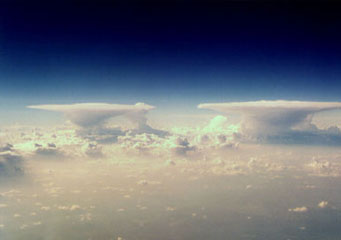
Above: Cumulonimbus Capillatus
Cumulonimbus Capillatus
Cumulonimbus is a combination of two Latin words "Cumulo" which means" puffy" and Nimbus which means "dark" in appearance. Cumulonimbus clouds are a dense and tall cloud formation that is formed due to atmospheric instabilities. This normally precipitates thunderstorms, snowstorms, hailstorms and other intense weather conditions. There are several varieties and species of cumulonimbus clouds. A perfect example of these clouds is the cumulonimbus capillatus clouds.
What are cumulonimbus capillatus clouds?
A cumulonimbus capillatus cloud is a type of cumulonimbus cloud that is massively formed. Actually, it is the only cumulonimbus cloud that seems to extend from the earth’s surface to the skies or the troposphere. It is tropical by nature and gives rise to massive monsoon downpours, strong winds and sometimes hails. The vertical movement around and inside these massive storm clouds is very hazardous to airplanes. The top of the cumulonimbus capillatus cloud can extend horizontally on high altitudes.
What height are cumulonimbus capillatus found?
Cumulonimbus capillatus are high altitude rain clouds; actually forms at around 10,000 meters to 12,000 meters above the earth’s surface. These massive horizontal extensions are usually formed in the evenings (after a hot and humid day with extreme temperatures, well within or above 30 degrees Celsius).
How are cumulonimbus capillatus clouds formed?
As the sun rays heats up the earth, hot air bubbles that are accompanied by water vapor rises upwards from the warm ground and go through convention or get diluted by the cold air on the top layers of the atmosphere. As long as the air within the parcel is warmer than the surrounding air, they continue to rise and form what is called a “cold front.” This is the transition zone where the cold air mass replaces and dominates the warm air. The cool air which is now dominating the air parcel or mass condenses the moisture and forms the cumulonimbus capillatus clouds and later induces precipitation.
As such we can safely say that cumulonimbus capillatus clouds form when a “cold front” meets a parcel of warm moist air that rises from the earth’s surface. They basically form from the cumulus congestus type of a cloud that normally dominates the lower cloud heights and grow vertically until they reach their height. They either develop alone or in a cluster of vertical clouds that have varying heights.
What do cumulonimbus capillatus clouds look like?
This type of a cloud is characterized by an upper section that has parts that appear “hairy” (fibrous structure or a mass of disorderly hair) and is shaped like an anvil. In very cold air, the striated structure of cumulonimbus capillatus extends throughout the skies. These types of clouds are normally accompanied by heavy downpours which may be thunderstorms, snowstorms, hailstorms, and often forms very discrete virga.
How common are cumulonimbus capillatus clouds?
These types of clouds are very common in the tropics, though they are also distributed in other parts of the globe, apart from the Antarctica. Their main characteristics are as follows:
- Forms in all regions of the word with an exception of the Antarctica.
- Caused by powerful convections that are assisted by atmospheric instability.
- They cause hailstorms, heavy rains and extremely strong winds that can cause a lot of havoc.
- They are high altitude rain clouds that cause a lot of problems to the pilots when they form.
