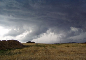
Above: Cumulonimbus Pannus
Cumulonimbus Pannus
Cumulonimbus pannus clouds are part of a cumulonimbus formation that can often rises to a great height, the cumulonimbus cloud can reach up to 12 kms from its base and the pannus are shreds torn from the main cumulonimbus cloud by strong winds.
What are cumulonimbus pannus clouds?
As with Nimbostratus pannus, cumulonimbus pannus clouds are fragments often referred to as fractus of the main cloud formation. For this reason cumulonimbus pannus will need to have a cumulonimbus cloud from which these fragments of cloud are formed. Cumulonimbus clouds are cause by convection, as the moist warm air rises it cools and the clouds of vapor form the cumulonimbus cloud pattern. If the convection is rapid the cloud will begin to generate strong internal winds that will literally rip parts off, forming these cumulonimbus pannus cloud fragments.
What height are cumulonimbus pannus clouds found?
Cumulonimbus pannus clouds can be found at very low levels often actually covering hills or mountain sides, in flatter conditions they can be observed beneath the base of the cumulonimbus cloud base from a height of about 400 meters to 1, 000 meters from ground level. The height can vary during their existence, as they can be affected by the strong up drafts and down drafts before and during a rain shower or thunderstorm.
Classification of cumulonimbus pannus clouds
Cumulonimbus pannus clouds are the collective title for cumulonimbus fractus clouds. Fractus clouds are strips or shreds of cloud torn by the wind from the main cumulonimbus cloud. Should these fractus shreds be seen together in a ragged group, normally under the base of the main cumulonimbus clouds they are called cumulonimbus pannus.
How are cumulonimbus pannus clouds formed?
There are a series of atmospheric conditions needed for cumulonimbus pannus clouds to form:
- A cumulonimbus cloud must be formed and it needs to develop strong air currents to destabilize its mass
- Down drafts and precipitation will cause parts of the cumulonimbus cloud to be ripped off and they can often be seen underneath the main cloud shortly before or during a storm or cloud burst activity
- They tend to have a short life and will dissolve and disappear as the storm or cloud burst subsides and loses its power.
What do cumulonimbus pannus clouds look like?
The Latin word pannus means cloth or strip. It is a good description for cumulonimbus pannus. These clouds do not have a solid image or a clear base, but rather resemble ragged strips of cloud often changing form rapidly.
How common are cumulonimbus pannus clouds?
During heavy showers or thunderstorm activity they are extremely common to be seen. If you live in a location where you can expect there to be thunderstorm activity you will almost always be able to observe cumulonimbus pannus clouds. They will not last for very long, however if you do see them you can expect some heavy rain burst or storm activity will shortly follow.
Where can I see cumulonimbus pannus clouds?
Look under the base of the main cumulonimbus cloud formation the cumulonimbus cloud will have a solid base although this may have holes or rips in it caused by strong winds. The cumulonimbus pannus clouds will appear as darker strips of clouds underneath this base.
