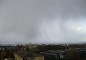
Above: Cumulonimbus Virga
Cumulonimbus Virga
Simply put, cumulonimbus clouds are the kind of clouds you get with stormy weather. Thick and menacing looking that can extend a long way up. So far in fact that the higher winds will flatten the top of them, giving them a kind of anvil shape. Virga are branches that trail down from cloud formations. They contain water droplets that are too heavy to be contained in the clouds they are attached to, whether they are cumulonimbus clouds, stratocumulus clouds, or any other type. The rain from the virga very rarely falls to earth as it is usually evaporated quickly. Therefore, cumulonimbus virga clouds are thick thunderclouds with branches streaming down from them.
What height are cumulonimbus virga clouds found?
Low level clouds, of which stratocumulus virga are a type, will develop lower than around 6,500 feet in the sky. This is what makes the thunderclouds look so threatening, as they appear to be just overhead, although in actual fact they are quite high up.
Classification of cumulonimbus virga clouds
Cumulonimbus virga clouds are a classification of clouds. Cumulonimbus are one of the main cloud types, whilst virga is a sub type. There are also other sub classifications too. These include:
- Praecipitatio
- Tuba
- Velum
- Pannus
- Arcus
How are cumulonimbus virga clouds formed?
Cumulonimbus virga clouds can be formed when the right circumstances and atmospheric conditions occur. Warm moist air has to be forced upwards and this can occur for three reasons:
- Change in landscape causing the temperature to change
- Change in weather front that is blown in from other areas
- Sunshine that warms the air causing it to rise
Once the air is warmed and forced upwards it meets cooler air in the atmosphere. If the air is forced upwards quickly and meets winds as well as cold air, then the clouds will form.
What do cumulonimbus virga clouds look like?
Cumulonimbus virga clouds are really thick dark gray clouds. They are heavy looking as they contain a great deal of water as can be evidenced by the huge downpour that results once they have become too heavy to be sustained in the atmosphere. Although storms originating from these types of clouds are usually completed within 20 minutes of starting, the amount of water, snow or hail that they shed can be a huge amount and can be a cause of flooding.
How common are cumulonimbus virga clouds?
Cumulonimbus virga clouds are commonly found in nice warm moist areas. Once the air is warmed and lifted high into the air it will meet with tropospheric winds that will help develop the clouds, turning them into storm clouds, particularly where the atmosphere is unsettled.
Where can I see cumulonimbus virga clouds?
You can find cumulonimbus virga clouds anywhere there is a good amount of warm and moist air, as it is this that rises up into the atmosphere to create the clouds together with the right amount of wind factor and heat exchange to allow the warm air to rise quickly enough. Tropical climates are prime areas for these types of clouds and you will often find thunderstorms erupting and flooding that quickly abates.
