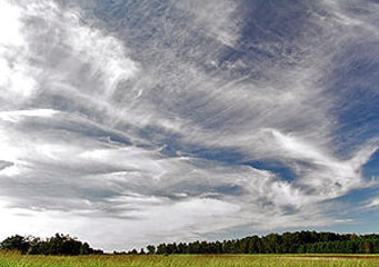
Above: Cirrus
Cirrus
What are cirrus clouds?
Cirrus clouds are a type of atmospheric cloud. Commonly seen as colored between a light gray to white, these clouds are usually formed when water vapor attains a specific altitude and meets colder winds. They are usually very thin and actually comprise of ice crystals and are regarded as being a sign that there could be rain or light snow later, depending on the time of year. It is estimated that these cirrus clouds will cover about 25 percent of the Earth at any one time.
Types of cirrus clouds
- Cirrus spissatus
- Cirrus castellanus
- Cirrus fibratus
- Cirrus duplicatus
- Cirrus floccus
- Cirrus aviaticus
- Cirrus undulatus
- Cirrus uncinus
- Cirrus vertebratus
- Cirrus intortus
- Cirrus radiatus
What height are cirrus clouds found?
Cirrus clouds are usually visible at between 16,500 feet and 20,000 feet. They are considered to be high level clouds. Clouds are usually moved by the wind and as far as cirrus clouds are concerned, they can travel at more than 100 miles per hour, depending on how strong the jet stream is at their altitude.
Classification of cirrus clouds
There are two primary types of cirrus clouds. These are
- Cirrostratus clouds which appears as a thick white blanket, causing the sky to look white.
- Cirrocumulus clouds look totally different. Instead of a plain white sheet like cirrostratus clouds, they look like tightly wrapped bubbles in the sky.
However according to the World Meteorological Organization (WMO), these can be classified even further:
- The cirrus fibratus that looks like a mare’s tail with no tufts or curls.
- The cirrus uncinus which has hooks and curls at its ends.
- The cirrus spissatus which are usually quite dense or thick and looks grayish or opaque.
- The cirrus castellanus which looks like lumps that are joined together by thin wispy hairs.
- The cirrus floccus which does not have a regular shape and appears raggedy at the bottom but well rounded or curved on the top.
- The cirrus vertebratus looks like fish skeletons, and many more variations of these.
How are cirrus clouds formed?
Cirrus clouds are formed when water vapor undergoes deposition and becomes ice crystals at the high altitude where they are formed. Such clouds are normally thin because the higher the altitude, the less water vapor there is. They are usually created when warm moist air rises over cold air and the deposition occurs.
What do cirrus clouds look like?
They are thin clouds that look like little trails of curly white hair or fine feathers, although depending on the specific types, this may vary.
How common are cirrus clouds?
These cirrus clouds are very common and are usually clearly visible when the skies are clear. It is possible to see wispy trails of clouds gliding by, and these are commonly cirrus clouds. The cirrus clouds glide by based on the direction of the wind and this is a good indicator of the direction the weather is flowing in from.
Where can I see cirrus clouds?
Cirrus clouds can be seen anywhere in the world. Since they are commonly formed by warm air meeting cold air, the depth of these clouds is determined by the temperature as well as ice saturation and atmospheric pressure. It is even possible to find cirrus clouds in the Arctic north and the Antarctic where they are larger than normal.
