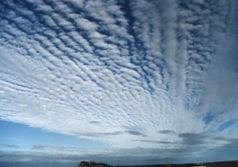
Above: Cirrus Radiatus
Cirrus Radiatus
According to some weather studies, it has been proved that cirrus clouds are often as a result of two different opposing climatic conditions( warm versus cool) or atmospheric developments. The first development is that of upper atmospheric disturbances that includes the formation of storms or an approach of a weather front. Cirrus clouds often appear before major atmospheric disturbances, for example typhoons, storms or hurricanes. The second development is that they can be brought about by exhaust matter or contrails left behind by passing jet planes. These are arguably bad for the environment, though it is a subject of continuing environmental debate.
Bright white filaments that come in various shapes and appearances and that are suspended high up in the skies, cirrus radiatus clouds are high altitude clouds formation. They are very spectacular with their presence creating amazing eye catching skies that are usually fluffed up by strong wind movements. Such cirrus clouds as cirrus radiatus are said to resemble an artist’s canvas with some transparent and diluted brush strokes.
What are cirrus radiatus clouds?
These are a type of cirrus cloud whose elements are arranged in rows that are merged together to come up with parallel bands of clouds. The straight and parallel bands seem to merge together towards the ends of the horizon due to the effect of perspective. These bands often cover the entire sky but tend to converge at a single point or two points of opposite dimensions that meet at a horizon. Cirrus radiatus clouds are partly made up of cirrostratus or cirrocumulus clouds.
What height are cirrus radiatus clouds found?
Cirrus radiatus clouds are one of the world’s highest clouds formations. They are situated at altitudes of over 16, 000 feet above the earth’s surface. They normally seem immobile, but that is because their movement is quite imperceptible to the naked eye. In reality, these clouds are quite fast, even faster than other low-lying clouds because they are exposed to fast moving and strong winds.
How are cirrus radiatus clouds formed?
Cirrus radiatus clouds form when vapor droplets freeze into ice crystals that are then moved about by fast moving heavy winds, resulting in their appearance. Their parallel filaments are basically as a result of precipitating ice crystals and this is why they are also often referred to as the clouds that precipitate. However, their precipitation does not reach the ground. The warm air the ice crystal get on their way down, evaporates them even before they could reach the earth’s atmosphere, in actual sense cirrus radiatus clouds are some sort of a never-ending melting cloud.
These types of clouds often form all through the year, irrespective of the year’s season. Typically, their cover on the sky is normally between 20-25 % at any time of the year. A recent study using infrared satellite monitoring system shows that the total cirrus clouds coverage at such places as the tropics is approximately 70% of the total skies.
Characteristics of cirrus radiatus clouds
- High altitude clouds-above 5000 meters.
- Appear as parallel bands.
- Found all over the world.
- Very eye catching.
- Limited to cirrus types of clouds.
