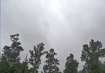
Above: Altostratus
Altostratus
Generally, clouds are classified according to how high they are in the skies, their shapes, texture and appearance. Most have Latin names in their suffixes or prefixes. These Latin names are given according to how they appear when observed from the ground. Although clouds have varied names, they are all formed the same way and through the same mechanism. And this mechanism is rising warm air from the ground meeting with cold air up there in the skies, then condensing to form varied types of clouds.
What are altostratus clouds?
Altostratus clouds are middle level clouds that are normally characterized by a homogeneous gray to bluish sheet that is normally lighter than nimbostratus but darker than cirrostratus clouds. Although they appear all over the skies, their semi-translucent nature allows sunshine to pass through them. They are made up of solidified ice crystals that have the capacity to produce light precipitation.
Actually, they are grey to bluish in color and form a thin veil over the moon and the sun, especially if formed in higher altitudes. And because altostratus clouds are usually comprised of tiny ice crystals, they are potentially dangerous to aircrafts. This is because they cause ice to form on the wings of the said aircrafts when they fly through them.
Types of altostratus clouds
- Altostratus opacus
- Altostratus praecipitatio
- Altostratus undulatus
- Altostratus radiatus
- Altostratus pannus
- Altostratus translucidus
- Altostratus mamma
- Altostratus virga
- Altostratus duplicatus
What height are altostratus clouds found?
Generally, altostratus clouds form between 2000m to 6000m above the ground and often results into long, steady rains or snow. As aforementioned, they form ahead of a warm front and produce widespread and continuous precipitation. If they form in higher altitudes, they are thinner, but if formed near the earth’s surface, they are thicker and darker in color.
How are altostratus clouds formed?
Altostratus clouds are formed as a result of the ground’s warm air meeting with mobile cold air up in the skies, then condensing. They are mainly comprised of tiny ice crystals at the top and small water droplets at the bottom. They are a good sign that large amounts of moisture is being held in their gray to bluish layers and normally cover large areas, mostly thousands of square miles. When formed near the earth’s surface, altostratus clouds are normally too thick, therefore hide both the sun and the moon from the view. When they form in higher altitudes, they are quite thin; therefore the sun or the moon is clearly visible through them.
What do altostratus clouds look like?
When stratus clouds cover the whole of the skies, it is usually difficult to determine whether they are low level or mid level clouds. As a general rule of thumb, if you are able to make out their texture, then it more probable that is a low level stratus cloud. If however there is no discernible structure and featureless and smooth, then it is more likely to be mid level altostratus clouds.
How common are altostratus clouds?
Generally speaking, altostratus clouds are a worldwide phenomenon and cover a large portion of the skies. If they are seen approaching from the direction of the wind and are increasing in coverage, then expect widespread precipitation over the entire area of their coverage.
