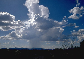
Above: Altostratus Praecipitatio
Altostratus Praecipitatio
Altostratus praecipitatio is a name given to a specific type of cloud. The first part of the name, altostratus, denotes the general morphology and other characteristics of these clouds. The altostratus clouds normally form in vast sheets, occur at average distances above sea level and normally contain water droplets as opposed to ice. The second part of the name describes the special characteristics of these types of clouds. As the name would suggest, the altostratus praecipitatio normally contain a larger amount of moisture than other altostratus clouds, meaning that they are more prone to causing rainfall.
What height are altostratus praecipitatio clouds found?
All altostratus clouds are formed at more or less the same height, and altostratus praecipitatio are no exception to this. Being middle clouds, the altostratus praecipitatio normally form at an altitude of between six thousand and sixteen thousand feet above sea level. Since this is more or less the height at which planes fly, they can be of considerable concern for pilots of all kinds.
Classification of altostratus praecipitatio clouds
As has been mentioned, the altostratus praecipitatio are middle clouds based on the distance they are from sea level. This distance is measured from sea level to the base of the cloud.
How are altostratus praecipitatio clouds formed?
Formation of altostratus praecipitatio generally follows the pattern of formation of most other cloud types, with very little variation. Essentially, to form the altostratus praecipitatio clouds a mass of air has to pick up some moisture and then find its way to the upper atmosphere. In the case of the altostratus praecipitatio, this would be in the region of 6,000 to 16,000 feet above sea level. At this height, the water in the air will condense, forming the clouds. For the altostratus praecipitatio, the water content is normally higher than the water content in other altostratus clouds, meaning that these clouds will therefore be more prone to causing precipitation. There are several methods that the air containing the moisture can reach the upper atmosphere:
- It could be pushed upward by currents of hot air rising from the ground
- It could be forced to move upward when it comes into contact with colder, heaver air. This forces the warm light moisture-laden air to ride on the surface of the cold air.
- Obstacles such as mountains could force the air to move upward when it flows against them
What do altostratus praecipitatio clouds look like?
Being full of water, the altostratus praecipitatio clouds are normally thick and heavy. As with most other altostratus clouds, they normally form sheets of cloud.
How common are altostratus praecipitatio clouds?
Altostratus praecipitatio are found in regions that have a moderate amount of humidity. They are more common in seasons which experience an increase in humidity, and also in areas where such features as mountains or cold air fronts come into contact with wind that has lots of moisture.
Where can I see altostratus praecipitatio clouds?
These clouds are usually observed in areas of moderately high humidity.
