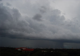
Above: Cumulus Praecipitatio
Cumulus Praecipitatio
The term praecipitatio is the Latin word that means "fall". Praecipitatio clouds are classified as supplementary clouds that arise as a consequence of any form of precipitation from the cloud. Precipitation can take the form of rain or snow, ice pellets or hail and even a simple drizzle that reaches the surface of the earth. In the context of cumulus praecipitatio clouds, these are merely the grouping of praecipitatio clouds that are found at a lower level. In addition, these clouds have its shortcut name as Cu pra that easily suggests that these clouds occur with precipitation.
What height are cumulus praecipitatio clouds found?
Cumulus praecipitatio clouds may be found as low as 6,000 feet and on occasion, depending on when convection occurs, can go as high as about 10,000 feet.
Classification of praecipitatio clouds
The praecipitatio accessory cloud formations can be seen in the following formations :
- Altostratus praecipitatio
- Nimbostratus praecipitatio
- Stratocumulus praecipitatio
- Stratus praecipitatio
- Cumulus praecipitatio
- Cumulonimbus praecipitatio.
How are cumulus praecipitatio clouds formed?
The cumulus praecipitatio cloud formation is influenced by the degree of moisture in the air. While cumulus clouds generally are formed by convection between the warm ground air and cooler air in the stratosphere, cumulus praecipitatio is formed in a similar manner although there is substantially more moisture in the air. The impact of this is that the visibility of cumulus praecipitatio clouds usually signify rain or snow depending on the cloud coloration.
What do cumulus praecipitatio clouds look like?
The cumulus praecipitatio clouds look like puffy cotton balls in the sky although more specifically because they are praecipitatio clouds, they usually carry rain or snow and in such instances, will look heavy and full. Depending on the degree of jet stream or wind, there is a possibility that these clouds are fast moving and therefore may bring scattered showers.
Simply by looking at a picture of such clouds, it is easy to conclude that these clouds look on the heavy side and they are definitely not a lightweight entry in the cloud family.
How common are cumulus praecipitatio clouds?
The cumulus praecipitatio clouds are generally common in most parts of the world although they are more frequently visible in tropical climates where there is a higher level of humidity in the air.
Where can I see cumulus praecipitatio clouds?
These cumulus praecipitatio clouds are visible everywhere and are usually a sign of incoming rainy or stormy weather. While the cumulus praecipitatio clouds look like other general puffy white or grey cloud formations, they are very distinct in the levels that they are visible and the impact of these clouds. In addition, you need to note that though cumulus praecipitatio clouds have very similar features with the cumulus clouds, the one distinct feature that defines it is that it will bring about precipitation that will reach the ground. This feature is also shared by two other members in the cumulus family which are namely the cumulus virga clouds and the cumulus mamma clouds.
